

A tropical low forming off the north-west of Australia has a “high chance” of becoming a cyclone in the coming days, the Bureau of Meteorology has warned.
The system, designated 18U, is forecast to reach cyclone strength either late today or tomorrow, according to a post the BoM made on X.
A tropical cyclone watch warning is in place from Cape Leveque to Wallal Downs, including Broome, on the Western Australia coast.
Islands off the coast are included in the warning.
Gale winds are forecast to develop in that area in the next 12 to 36 hours.
The Bureau warned the system may reach category three cyclone strength late Tuesday or Wednesday.
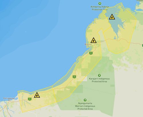
A flood watch warning is in place for catchments in the Kimberly in the state’s north, as well as the Pilbara region.
“Although there is no immediate danger you need to start preparing for dangerous weather and keep up to date,” the WA Department of Fire and Emergency Services said in a Facebook post early this morning.
People are urged to secure vehicles, boats, gas bottles and loose material around their home.
They should also have an emergency kit prepared which includes canned food and water to last five to seven days, a first aid kit, medication, cash and a battery-operated radio and spare batteries to listen to warnings.
Stay up to date on the Emergency WA website and the Bureau website, and find out more about preparing for a cyclone online here.