[ad_1]
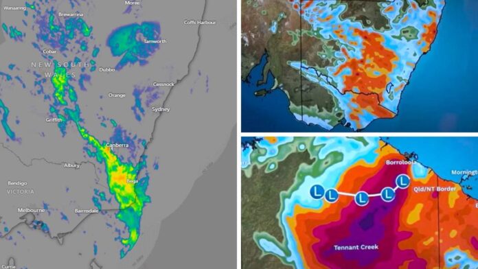
Meteorologists have warned a weather change could come with “quite a punch” on Wednesday as a possible southerly buster system rolls through New South Wales and temperatures plummet in Victoria.
Meanwhile, the remains of ex-tropical Cyclone Megan continue to bring heavy and intense rainfall and possible flooding to the Top End.
In the south of the country, a strong cold front has already altered this week’s weather.
The mercury in Melbourne peaked at 28.5C on Tuesday at 12.30pm, Avalon airport got to 30.4C while Yarrawonga, on the Murray, peaked at almost 35C.
But on Wednesday the city will struggle to get to just 18C now that front has passed through dragging down temperatures with it.
There’s a possibility of morning showers and a low of 14C in Melbourne. That will go down to a chilly minimum of just 11C early on Thursday morning but the maximums should creep back into the twenties.
“It’s much, much colder. We’re dropping a good 10 or 12 degrees off of Wednesday’s maximum temperatures,” the Bureau of Meteorology’s Angus Hines said.
“This is a sure sign that we’re moving away from summer and deeper into autumn over the next few days.”
There could even be snow on some of the Tasmanian peaks on Wednesday.
Hobart is set to top out at 17C on Wednesday with a 10C low. Up on Kunanyi/Mount Wellington, overlooking Hobart, snow could fall as low as 800 metres as the temperatures head down to 2C.
Southerly buster
But some of the most hectic conditions on Wednesday could be along the NSW coast as the cold front heads north from Victoria, said Mr Hines.
“About lunchtime it reaches Sydney and it could be a bit of a southerly buster, meaning it comes with quite a punch.”
Southerly busters are dramatic and abrupt weather changes sometimes accompanied with fierce winds and with temperatures drops over a short period of time. They are sometimes accompanied by huge roll clouds.
“We’re looking at a strong burst of chilly winds which could be gale force over those coastal waters, as well as a lot of rain and possible thunderstorms moving through NSW on Wednesday afternoon,” said Mr Hines.
Sydney should see a high of 27C on Wednesday and low of 20C with up to around 10mm of rain with that front.
Cloudy days will follow with low to mid-twenties maximums.
Canberra is looking at a 24C high on Wednesday with some rain and 20C on sunny Thursday.
The front should push through relatively quickly on Wednesday, taking the rain with it, and then heading further north.
“Rainfall for the next couple of days with this system will be a widespread 10 to 25mm across the southeast but those thunderstorms could bring isolated areas of up to 50 to 60mm,” said Mr Hines.
Brisbane will escape the front with temperatures on Wednesday getting to 30C and then the high twenties for the rest of the week.
There could be some showers on most days, however.
Townsville is set for a run of 31C days with the odd shower.
Ex-TC Megan brining ‘intense’ rain, flooding
Ex-tropical cyclone Megan continues its track across the Northern Territory.
Hundreds of millimetres of rain have so far come down in areas directly under Megan’s track near The Gulf of Carpentaria.
The BOM has issued a flood watch for the Carpentaria coastal rivers and central parts of the NT. It’s added that “heavy, locally intense rainfall with possible damaging wind gusts,” could occur around Tennant Creek.
Megan is tracking a line just north of Tennant Creek and towards Kununurra where it could reach late on Thursday or Friday.
“Widespread daily totals of 60-150 mm are possible during the next few days across the area. Isolated heavy falls in excess of 200mm are possible,” it warned.
Highs in the mid-thirties for Darwin with possible storms and showers heading into the weekend.
Calm and sunny conditions are expected in Perth with maximums bobbing around the 30C mark and lows in the mid to high teens for the coming days.
A cloudy Wednesday in Adelaide reaching 22C. The sun will return on Thursday with a top of 24C and a brisk dawn low of 11C.
[ad_2]
Source link


