[ad_1]
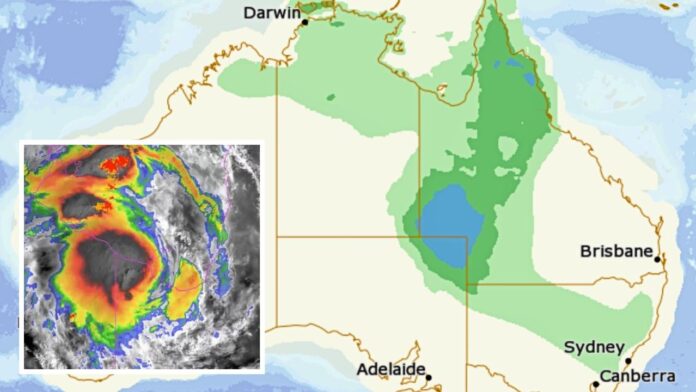
Queenslanders have been urged to brace for “life-threatening” flooding as ex-cyclone Kirrily continues to wreak havoc on communities in the Gulf Country — all while another potential cyclone brews off the coast.
A flood watch is in place for parts of the Gulf of Carpentaria and western Queensland, with flood warnings ranging from minor to major for more than 20 rivers and creeks.
Between 150mm and 250mm of rain is expected to fall on some regions in just 24 hours, with isolated totals of 300mm or higher.
Major flooding is expected at Condamine, Warkon and Walkers Bend over the weekend and into early next week.
Some regions have already seen heavy rains and intense wind.
A staggering 332mm fell at Westmoreland Station, near the Queensland-NT border, in the 24 hours to 9am on Friday, while 150mm fell at Mornington Island Airport.
Gale force winds were also recorded at the island’s airport, with a peak gust of 94 km/h at 7:35am on Friday.
Three states in firing line
The storm front caused by Kirrily is expected to migrate farther south through the weekend, bringing heavy rain and floods to parts of the NT and NSW as well as Queensland.
In the NT, flooding is possible for the Nicholson, Barkly and Georgina rivers and Settlement and Eyre creeks, with the Bureau of Meteorology warning some communities may become isolated by floodwaters.
“Significant river and stream rises are possible with heavy rainfall across the flood watch area in the next few days,” the BOM warned.
“Many roads, and possibly primary and secondary highways, may be affected. Some communities and homesteads may become isolated.”
An initial flood warning was also issued on Friday afternoon for the far west of NSW, due to Kirrily and a fresh inland trough.
“This trough may potentially bring significant rain to some western areas, before the system weakens and shifts to the state’s east on Tuesday,” the BOM said.
Minor flooding is expected on NSW’s Paroo, Warrego and Barwon rivers and Cooper Creek.
Second cyclone brewing
Meanwhile, yet another potential cyclone is brewing off Australia’s east coast.
A low pressure system formed off the island of K’gari on Thursday, with a chance it could form into a tropical cyclone.
The system is expected to begin moving west across the Coral Sea towards northern Queensland next week, with a low (10-15 per cent) chance it will develop into a cyclone from Wednesday and a moderate (25-35 per cent) chance from Thursday.
However, “at this stage, there is enough uncertainty to take the forecast of a tropical cyclone with a large grain of salt,” the BOM said.
“It’s best to be aware of but not alarmed by this system.”
[ad_2]
Source link


