[ad_1]
Aussies have been urged to brace for an “intense” set of storms that could lash towns with as much as 300mm of rain in just a few days.
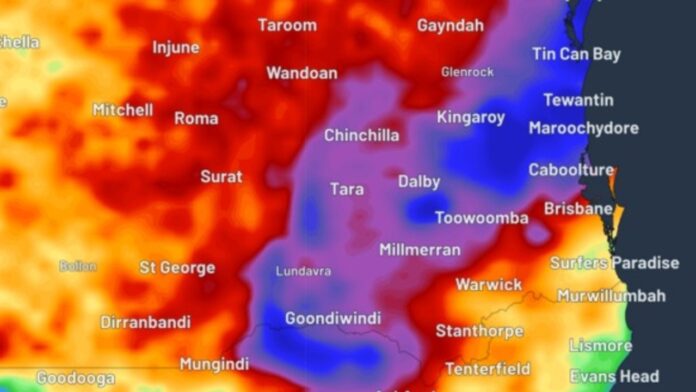
Western and southeast Queensland and far north NSW are forecast to be battered by heavy and intense rainfall for the next three days due to two rain events.
Widespread falls of between 100mm and 150mm are expected between the Gold Coast and Gladstone. Isolated falls of between 150mm and 300mm are also forecast, and rainfall at some locations could even exceed 300mm.
The rain is being driven by ex-cyclone Kirrily, which has settled over western Queensland. A separate system is also developing over the eastern NSW-Queensland border.
“We’re expecting persistent showers and storms across northern parts of the country,” explained Bureau of Meteorology meteorologist Sarah Scully.
“It’s ex-tropical cyclone Kirilly, this low pressure system here, that’s continuing to bring heavy rainfall and flooding to central and western parts of Queensland.
“Kirilly is also drawing a deep layer of tropical moisture across much of Queensland and northern NSW, which is combined with this lingering trough to bring widespread showers and thunderstorms, potentially severe and heavy rainfall as well.”
The worst of the storms is expected to hit between Tuesday evening and Wednesday morning.
The rainfall could cause flooding, BOM meteorologist Dean Narramore warned.
“Forecast rainfall could lead to flash and riverine flooding in the next 48 hours. In the worst cases, that could lead to inundation of homes, properties, businesses and agricultural land,” he said.
Flood watches are in place for southern and central Queensland and NSW’s northern rivers, with flood warnings active for more than a dozen catchments.
Queensland has been hit by a staggering amount of rain in recent weeks, waterlogging the area.
Seymour Gap in western Queensland received 256mm in the hours to Monday morning, while Kirby received 244mm.
A weather reading at Brisbane airport showed the precipitable water value — which measures how much water is in the air — had hit 70.8mm on Monday morning, just shy of its record of 70.9mm in March 2017.
The rain will begin to push into northern Queensland from Wednesday and won’t let up until Thursday, when a dry weather system finally pushes through and clears up both the storms and humidity.
Heatwave to combine with rain
Meanwhile, parts of Australia — including some that will be impacted by the rain event — are set to swelter through a brutal heatwave.
Maps from the Bureau of Meteorology show widespread temperatures in the low-40s across the interior, and the heat is expected to migrate farther south from Thursday.
An extreme heatwave warning is in place for Queensland’s North Tropical Coast and Tablelands, as well as severe warnings for the Central Coast.
Those severe warning extend into the Barkly and Tanami districts in the NT. The Barkly catchment is also under a flood watch.
WA will be the state worst impacted by the heat, with large parts of the north and most of the coast covered by some kind of heatwave warning.
An extreme warning is in place for the Gascoyne district, and severe warnings for the Kimberley, Pilbara and large parts of the southwest coastline.
WA residents have been urged to prepare for extreme fire danger for Swan Inland South, Brockman, Blackwood and Southern Forests on Tuesday.
[ad_2]
Source link


