[ad_1]
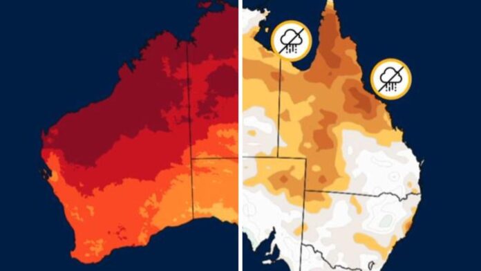
Temperatures during Autumn across much of Australia could be “unusually high,” – in fact up to three times more likely than normal to be above average.
That’s according to the Bureau of Meteorology (BOM) which has just released its climate outlook for the coming season.
The climate driver El Nino, which has been a mixed bag over summer, will likely weaken during autumn before petering out completely with some predictions La Nina could even make a comeback.
The BOM’s climate outlooks provide a long range snapshot of the expected general weather over several months as well as a recap of the most recent conditions.
January rainfall was above average for most areas with parts of Victoria and part of the Northern Territory having their highest January rainfall on record.
Temperatures were also above average for January over most of the country.
Looking ahead, it’s still looking hot, says the BOM.
“Warmer than usual days and nights are very likely across Australia for March to May,” the outlook stated.
“Most areas have an increased chance of unusually warm days from March to May especially northern Australia.
“Nights also have an increased chance of being unusually warm for many areas”.
The temperatures are three times more likely than normal to be “unusually high” and above the median, particularly in the country’s north and west, said the BOM.
Rainfall is set to be below the median across northern Australia from WA’s north through the Top End to Far North Queensland. But the drier conditions could also spread down through much of western Queensland and north west New South Wales.
But the BOM warned, the cyclone and monsoons season overlap autumn so there could still be instances of significant rainfall in these areas even in the three month average is lower than usual.
“The more neutral outlooks for other areas means there is not a consistent wet or dry signal for these areas,” said the Bureau.
El Nino and La Nina
El Nino is continuing but only “for now,” the outlook stated. This Pacific Ocean based El Nino-Southern Oscillation (ENSO) climate driver can swing between El Nino, La Nina and neutral phases.
“It has less influence on Australia’s rainfall during summer and autumn. “
Sea surface temperatures in the Pacific, a key indicator of El Nino, have peaked and are cooling.
“We expect the Pacific Ocean to return to neutral conditions during autumn.”
Earlier this month, the US Climate Prediction Centre said that a transition from El Nino to ENSO neutral was likely but there was now a 55 peer cent chance that a L Nina could form later in the year.
The BOM, which has a slightly different definition of ENSO phases, has not made a prediction of whether La Nina could return.
The Indian Ocean Dipole, a similar climate driver than also affect rainfall, is neutral mode and is expected to remain that way at least until April.
“Record warm global ocean temperatures are likely contributing to the forecast of unusually warm conditions.”
[ad_2]
Source link


