[ad_1]
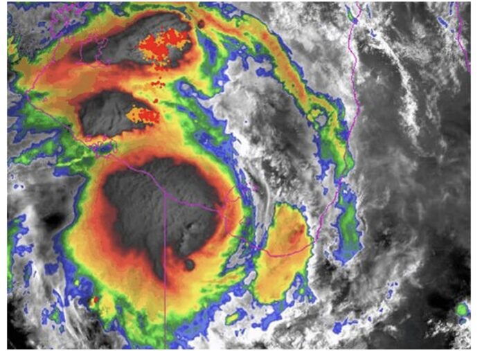
Ex-tropical cyclone Kirrily continues to threaten parts of Queensland with dangerous and “life threatening flooding”, amid fears a new cyclone could be brewing off the east coast.
A severe weather warning was issued for the southwest Gulf Country near the Northern Territory on Saturday morning, as the system makes its way further southwest.
Meanwhile, the North Tropical Coast seems to be spared for now after the Bureau cancelled an earlier severe weather warning for the region.
The Bureau stated rainfall is “unlikely to exceed heavy rainfall thresholds later this afternoon” and the situation will continue to be monitored.
In the 24 hours to 9am Friday, more than 300mm of rain was recorded in some parts of the region, with the Bureau warning the weather system would likely bring heavy rainfall leading to flash flooding in western parts of the Gulf Country, north west, and Channel Country districts.
But the bureau has warned locally intense rainfall which could lead to “dangerous and life threatening flash flooding” is also possible, particularly on the southern and western sides of the system.
“Isolated six-hourly totals between 150 and 200 mm are possible with 24-hourly totals exceeding 300 mm,” the bureau warned.
The storm system could also bring with it damaging wind gusts in excess of 90 km/h.
Residents in Mt Isa have welcomed news that supermarkets will be stocked again on Sunday after roads were reopened to allow trucks to arrive safely.
Meanwhile, meteorologists are closely monitoring a low pressure system that formed near K’gari during the week.
It’s unlikely the low will become a cyclone at this stage given it formed so far south.
But given it was tracking north-east, away from the Queensland coast, Weatherzone this week said if the system developed further it could form a cyclone in the Coral Sea before heading back towards land.
“Models suggest this system will spend at least a week sitting over warm tropical waters in the northern Coral Sea. Most likely this system will bring direct impacts to New Caledonia and maybe Vanuatu, before it tracks west back towards the Queensland coast,” the weather reporting service said on Thursday.
“At this stage, there is enough uncertainty to take the forecast of a tropical cyclone with a large grain of salt. Its best to be aware but not alarmed about this system.”
If a cyclone did form, it would be the third to batter Queensland this summer, after tropical cyclone Jasper brought record-breaking rain and heavy flooding to Far North Queensland around Christmas.
Kirrily hit the coast as a category 3 storm late last month.
[ad_2]
Source link


