[ad_1]
Warnings of “very dangerous storms” have been issued for parts of Queensland, with residents facing potentially destructive winds, intense rain and giant hail on Christmas Eve.
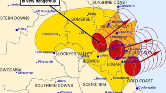
Rolling updates from the Bureau of Meteorology from noon local time, forecast the severe thunderstorms for residents in Redland City, Brisbane City and parts of Logan, Somerset, Gold Coast, Sunshine Coast, Moreton Bay and Ipswich Council Areas.
Intense bouts of rainfall could create dangerous and life-threatening flash-flooding near the Samford and the D’Aguilar Ranges, with the thunderstorm moving in a north-easterly direction.
“It is forecast to affect Strathpine, Redcliffe and Caboolture by 12:05 pm and Comboyuro Point, waters off Bribie Island and northern Bribie Island by 12:35 pm,” the weather authority warned.
Another set of thunderstorms is forecast to hit Cleveland, Mud Island and southern Moreton Island by 12:05 pm and waters off North Stradbroke Island by 12:35 pm.
Residents are urged to not drive, and stay indoors until the storm has passed. People should also avoid standing near doors and windows during giant hail.
Asthma sufferers are also urged to keep medication nearby, as storms and wind can trigger attacks.
Potentially severe storms have also been forecast for Victoria, “the vast majority of NSW”.
The Bureau of Meteorology’s senior meteorologist Angus Hines said the activity was forecast to peak on Sunday afternoon.
“The particular area where we’re likely to see severe thunderstorms is around Southeast Queensland including the Brisbane region and northeast NSW,” he said.
“We could see some of those thunderstorms get really big, really intense and they could potentially cause damaging to destructive wind gusts heavy to locally intense rainfall and large or even the giant sized hail as we saw yesterday.”
On Sunday morning, BOM issued a severe thunderstorm warning for parts of central Queensland, with the potential for damaging wind, heavy rainfall and large hail.
This follows a spate of severe storms on Saturday, with high temperatures fuelling the weather activity.
The current warning is for areas across the southern Darling Downs, and Granite Belt district, however the weather authority said the activity will likely move eastwards in over the next few hours.
In NSW, showers and severe thunderstorms will mainly occur in the central and eastern inland areas, with lighter storms forecast near the coast and far west.
Up to 30mm of rain is forecast for Sydney on Sunday, with the chance for showers easing into the night.
Melbourne’s Carols by Candlelight also faces a potential washout, with a high chance of showers, and a possible thunderstorm forecast for the late afternoon and evening. The outdoors event will begin at the Sidney Myer Music Bowl from 8pm, with organisers adamant the show will go on rain, hail or shine.
The Bureau warned a low pressure system developing on the NSW/ Victoria border will drag the storm risk “across much of Victoria” on Christmas Eve, bringing wet weather as the day progresses.
“Showers of course, by their nature, tend to be a little spotty a little hit and miss – so there’s still a chance we’ll get the carols in the dry but there’s a risk of showers across Melbourne City at that time of day,” said Mr Hines.While the eastern states could face a wet Christmas, multiple severe heatwave warnings remain in place for Western Australia.
The Bureau have issued a warning for the Pilbara, Gascoyne, North Interior and South Interior Districts, where temperatures could reach up to 45C.
The alert is currently in place until Boxing Day.
[ad_2]
Source link


